A.Woman.Aging

Just another WordPress.com site

My Trip Westward, Week 3 January 5, 2016

Filed under: Being alone,Getting older,Outdoors,Travel — a.woman.aging @ 2:44 am

2015-10-03 11.07.28

October 2, 2015          To Helena, Arkansas

Somehow, I had never realized there are thousands of acres of pancake-flat land along the Mississippi where cotton, rice, and soybeans are grown. I decided not to go to Memphis, and the next bridge south across the river was at Helena, quite some way south. Thus, I ended up driving for many miles in this flat land called the Arkansas Delta. There were seas of cotton, often alternated with huge fields of rice and some soybeans. By 1860, Arkansas was the 6th largest producer of cotton, made possible by a considerable amount of slave labor. The number of slaves grew from about 20,000 in 1840 to over 400,000 in 1860. It is also one of the largest rice producers. There is some thought that many of the rice-growing techniques, such as levying and flooding the land at the right times, was learned from slaves who had grown rice in their home countries.

Huge machines that looked like monsters worked the land sending up billows of dust. The irrigating mechanisms with their metal spines and ribs reminded me of the long and huge dinosaur skeletons my little grandson had recently shown me in one of his favorite books. Occasional houses broke up the tedious landscape, mostly little clapboard affairs with peeling paint. And then, rounding one of the few curves, a grove of trees which framed a lovely little church and old cemetery. I made my lunch there and strolled among some of the very old gravesites, pondering the lives of these people.

Again, I was the only guest at my night spot, this one greatly different from the night before. The weather was too chilly, overcast, and windy to camp so I went to the only B&B in Helena and what a treat that turned out to be. The new owners had only been there for 2 weeks, and with no other guests, I could explore all I wanted and talk to them at length. Escaping from Dallas corporate life, they were trying something totally different. The mansion was built in 1904 by a cotton baron. The interior was full of intricate woodwork, beautifully preserved. Every fireplace was different. Then, as now, there must have been an enormous contrast between the rich and poor. A building as wretched as any I have seen in third world countries was only a few blocks away. Like most other towns I saw along the way, much was abandoned and falling down. The liquor store was the busiest place in town. I know, because (I ended up walking from my Inn about 20 blocks total, having been told it was a shorter distance!) it was a bustling place- walk-in and drive through. After I bought a bottle of wine, the clerk stepped outside with me and talked at length about the town. A very nice guy. Everywhere I have been, people are so friendly and helpful. By the way, Arkansas is from Indian words meaning “land of downriver people” or “people of the south wind” depending on the tribe.2015-10-02 15.54.51

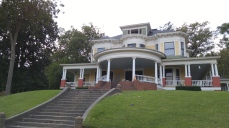
October 3, 2015     Into Mississippi

I had no idea when I fantasized about my trip, that I would end up in Mississippi! It is an interesting experience to wake up in the morning and not know where one is going or where the coming night will be spent. I’ve reflected on this quite a bit but haven’t come up with anything profound. I do know I am very glad for the experience.

Since the bridge took me to the northern part of Mississippi and I had never been there, I decided to go more or less across and see what unfolded. Luckily, there was a welcome station as I needed a map. A most pleasant welcomer greeted me and her smile revealed a solid gold tooth seemingly in the middle of her upper teeth that fit perfectly in a gap among her lower teeth. I found her charming. She soon had me married off to a man standing beside me and laughed and laughed when I told her we weren’t together. I noticed that he didn’t laugh. I chatted for a while with a couple from Lyon, France who were doing the entire blues trail from Natchez to Chicago!

I had seen enough of flat cotton and rice fields and grain elevators, so put on an audio version of a book by Stephen Hawking, “The Universe in a Nutshell” and was soon trying to grapple with thoughts of evaporating black holes, multiple dimensions, P-branes (what in the world?) and the limits of the universe(s). It was too much. Apparently I wasn’t as bored with the scenery as I thought, as my focus wandered at the things I was seeing and I couldn’t follow the book. I know no more now than I did about these esoteric matters except that there are now various theories in quantum physics having to do with ‘string’ theories and multiple dimensions and no way, at least so far, to prove any one right. Physicists live with theories, not exactness. Sounds like my trip.

At last the land warped into rolling hills and the roadsides were covered with more kudzu than I had ever seen, seas of it going as far as one could see until heavy forest was reached. Trees in the kudzu’s way had become bent green goblins, the spookiness traveling with me down the road. I saw a restaurant and stopped for vegetables, desperate and craving. Bad as they were, they were good.

I ended up in Oxford and the Faulkner home, Rowan Oak. He named it after these trees, though none were on the property. A beautiful place built in 1840, he moved in 90 years later and added electricity, water, and an addition. Whiskey and his typewriter, in part, inspired his writing. I tried to soak up writing vibes while I wandered around. A fitting place to visit– I just finished “As I Lay Dying” a few weeks ago. Then, greatly surprising myself, I ended up at Elvis’s birthplace in Tupelo! What a day. Got spoiled by the very nice hotel I checked into. By the way, those that research these matters think that “Mississippi” is an Indian word meaning “the Father of Waters.”

October 4, 2015 The Natchez Trail

I discovered that Tupelo was where the headquarters of the Natchez Trace Parkway was and went straight there in the morning. I had barely heard of it, and now think I always confused it with the Natchez Trail that follows antebellum homes. The narrow 444-mile-long national park is credited to the local DAR ladies in the early 1900s who wanted to preserve the disappearing ancient pathway from Natchez to Nashville. This Indian trail had been in use for thousands of years before modern ways made it obsolete.

It was another raw, dreary day. Grey and somber, it was still a pleasure to drive with no trucks, no billboards, and the early fall colors. Patches of bright yellow tick-seed sunflowers struggled here and there to fight the dreariness. A Wisconsin couple on recumbent bikes had just stopped at the headquarters. Apparently, the Trace is a mecca for bicyclists and they were there to do the entire thing with another couple. These two were at least my age and the man was pot-bellied! They average about 40 miles a day and an escort brings their supplies for overnights. Modern cycling includes cell phone communication, flashing laser white lights in front and red in back. Many bicyclists were on the road with their blinding lights as I drove along.

I found myself feeling heavy and sad as the miles passed. Flags were at half-staff at park headquarters because of the latest mass shooting. The Trace’s history, posted in various ways along the route, about both Native Americans and whites is about struggles, death, war, treaties and broken treaties with the Indians, suffering, and, in the case of Meriwether Lewis, suicide as he was making his way to Nashville. I stopped often at the marked places of interest– Indian mounds, the monuments, a cave and spring the Indians used, and the reconstructed cabin that served as an inn where Lewis shot himself. At one point, there were a dozen or so vultures in the road attracted by an unlucky raccoon. I slowed to let them get out of the way which they did walking slowly and without concern. In my rearview mirror, I saw them regathering around the animal, the group moving as one with a grace that resembled gently flowing water. I was astonished by the whole display.

I walked solemnly on a part of the original Trace. I considered the courage and fortitude it must have taken to walk on this path for miles and miles whether for trading, for war, for mail delivery (after the white people took over), and so many other reasons. The Trace is too narrow for wagons—it was either foot or horseback. I read where men called the Kaintucks in the Ohio River Valley around the 1800s would build flat boats and float their goods to trade— furs, wheat, whiskey, and more— down to New Orleans; then, as the Mississippi River current was too strong to go back up the river, take the boats apart, sell the wood, and, if they couldn’t afford a horse, walk back to Ohio, using the Trace as far as it would take them.

Finally, I could take no more and decided to leave the Trace and focus on beauty and happy things as much as possible. I had crossed a corner of Alabama and was now in Tennessee. The gloom and cold remained and I was about to check into a motel when the sun broke through! So, at the last minute I was able to find a nearby state park and camp by the Duck River which was good for my spirit. By the way, the origin of the names Alabama and Tennessee are not known with certainty. Alabama may be from a Creek word meaning ‘tribal town’ or a Choctaw word meaning ‘thicket clearers.’ Tennessee may be a modification of a Cherokee word meaning ‘winding river’ or ‘river of the great bend.’ From what I have seen, both are suitable.

October 5, 2015 Across Tennessee

This morning I find myself up at 6am EST because it is Central Time here. It is barely light and I watch the half-full moon grow dimmer as the sky lightens. The fog grows denser over the river or is it just that increasing light makes the fog easier to see? I am never outside at this hour so I have a lot to learn! Fire burning, coffee ready, now I am literally a ‘happy camper.’ I am glad to have my own camp coffee- a French press pot and good beans from home. Across the river the sky is showing a pale pink glow. Large water drops fall from time to time making tiny plop sounds. It must be the dew collecting on the leaves above me until it gets to a critical mass, then ‘plop and plink’ sometimes even on my head.

I am starting to get homesick if that is what is means to be longing for my dear family, my cello, my daily routine, friends, and home and gardens. I am surprised to find myself like a barn-sour horse on a trail ride, that you have to be ready to hold her back or she will take off at a gallop when she knows that the homeward stretch and barn are near. I am propelling myself faster toward home than I had intended so now it is clear I will get home a few days sooner than what the calendar shows. So, crossing Tennessee was a travel day. I made no special effort to find interesting things to see or do except to identify a state park to camp in as the weather was beautiful. Nonetheless, I did have a small adventure.

My route to the park took me through Oak Ridge. My children had a great-uncle who was a physicist there through much of his life so I decided I would look for a public visitor center. Well, Miss Google Map was again not reliable. I asked Miss GM for the Oak Ridge National Laboratory Visitor Center and up came the route, 3 miles from where I was. Off I went and was soon at a security gate. “Mam,” says a heavily armed but very nice guard— guns strapped on his legs, a thick pouch on his chest— “since you have arrived unauthorized, I will have to check your license, take your photo, and photo your car before you turn around and leave.” Can you imagine how happy I was that they didn’t need to search the car! It would have taken hours with my now chaos of stuff and I would have been so embarrassed.

My campsite was on the edge of a TVA lake, it was warm and sunny, and for the first time, I got there early enough to cook a real dinner. I craved greens so much I had canned spinach! It is not at all as bad as I remembered. Maybe it helped that I warmed it in a dollop of coconut oil.

October 6, 2015 From Andersonville, TN to Hot Springs, NC

Leaving Big Ridge State Park looked, on the map, like one of those ‘you can’t get there from here’ places. It is Union County, way out of the way– union supporters in the Civil War and helpers to escaping slaves. Hairpin curves and beautiful mountain scenes turned into strip malls near Knoxville. I had little choice but to get on I-40 but was surprised and rewarded coming up over a rise by a breath-taking view of the mountains as far to the north and south as the eye could see. This was just before I-81 split off. Leaving the interstate madness as soon as I could, going on Route 70, as the miles went by I reflected on how certain scenes—a porch, a hillside, an old swing, a tiny brook—have always evoked in me a deep stirring of memory that I have never been able to grasp. Then a longing and wondering sets in until a bit of time has passed and the feeling fades. Today, it was a porch of a certain style attached to a simple white clapboard house on a hillside looking towards a high mountain. What is this tug at my heart?

I was headed into Hot Springs, NC. Having lived in NC for 45 years plus and always wanting to see Hot Springs and Marshall, both in Madison County, here was my chance. Hot Springs turned out to be a cute little town at the confluence of a bold stream, Spring Creek, and the French Broad. Indians began used the healing springs 2,500 years ago. By 1778 traders were stopping for the waters. The town was named Warm Springs for the 98˚ springs, then changed to Hot Springs when a 117˚ spring was discovered. In 1884 a large hotel was built for people coming from all over to ‘take the waters.’ Sadly, it burned and another was built which was used to inter German soldiers in 1917. Three years later it, too, burned down. Now the springs are in private hands, the current hotel dating from 1990 and people still come from all over the world for the waters, though far fewer than in the heyday.

I found a cute room at the Alpine Court and walked all over the town which was about 2 blocks long and wide. By the end of the warm sunny afternoon, I felt like I had talked to half the people in town, all friendly– an interesting combination of local mountain people and hippy-granolas. The Appalachian Trail literally goes down the main street.

Being the last night of my trip, I splurged on a proper dinner (local trout and collards, at last!) and even dessert. The restaurant was in a building dating from the late 1800’s. Two blues musicians played and sang and, boy, were they good! Especially the harp. I learned the two went from Chicago to Florida on their performing path. While I ate, I mused about the paths my life has taken— some by choice, others by happenstance or necessity. There are probably other things I could have done reasonably well, and plenty I could have never done. In the midst of my thoughts, I see the young male waiter bounding up 25 stairs (I counted them) carrying a large box. That, I know, I could have never done along with plenty more serious things.

Walking back to my 1950’s motel, the blues harp still singing in my mind, I reflect gratefully on what a perfect last trip afternoon and night this has been. Will I be any different when I get home, will I spend more time on things that bring me joy? I already know I want to do a trip like this again.

October 7, 2015 Hot Springs to home!

The morning found me walking the town in the fog, clutching my travel mug, looking for a place to get a cup of coffee. Things were not looking promising. I didn’t see another soul and only 2 stores were open—the town’s two hardware and goods stores. I rounded a corner to one, determining to ask about coffee inside, when a tall lanky man suddenly appeared clutching a large shoe box under one arm. “Excuse me, ma’am, (in what I would soon learn was a Texas drawl), do you know where I can get a cup of coffee? I’ve just slept a few hours in my car on my way to see my son in Brooklyn. My horse on my farm hurt my leg and I came here to ‘take the waters.’ (He hoists up his pant leg to show me the damage.) My shoes fell apart and I just got a pair at the store (he motions to it).” He goes on. He tells me he wants to walk the Appalachian Trail and asks if I think the shoes he just bought are suitable. I don’t. “I am 67. Do you think I can do it—walk the trail?” I tell him it takes study and preparation and training. I go on about these things a bit as he is interested and doesn’t seem aware of the reality of walking the AT at all. He is humble, deferential. Clearly, not a man with much money. “Thank you so much, ma’am. I don’t want to take more of your time. God, bless you. Please pray for me.” I walk away not thinking of wanting coffee just now.

Heading out to Marshall, I did find coffee. Rounding a curve some 15 or so miles from Hot Springs, Marshall, the Madison County seat, suddenly appeared in my view– a tiny town in a narrow valley made by the French Broad River. I was astounded by my first ever glimpse of it. It looked almost European.2015-10-07 09.07.24

Eventually, I made it past Asheville and onto I-40 and intended to zip on home. Apparently, I wasn’t quite ready to give up my trip as, on an impulse, I turned down Highway 18, past South Mountain Park, past a pumpkin and apple stand where I bought a beautiful eating pumpkin from an overall clad farmer who had gotten up at 3am to drive to Hendersonville to get the apples, and, then, onto Route 150 which skirts the top of Lake Norman. All of a sudden I am gazing at a HUGE plant full of contraptions past a sign “Marshall Steam Station” that made me feel I had entered a land of giants. I looked this up later. It is a coal power plant owned by Duke Energy. I am not sure I had ever seen one before. I learned that the Marshall plant is the second largest Duke Power coal facility in the Carolinas. It generates enough electricity to power approximately two million homes. I couldn’t help but wonder where that coal ash goes.

Driving along, I realize one of the reasons I like to travel so much is to see and feel the lay of the land, how is changes, how the soil changes, how that determines the economics of the area, what plants grow where, how long it takes the mountains to rise and smooth out again, what the tiny towns look like, what people put on their porches– so many more things. Feel it in my bones. Smell it.

Feeling full of gratitude and thanks, I arrived home safe and sound in the afternoon from these 2,550 miles trip with no mishaps. I so appreciate all of you who followed my journey and kept me company with your insights and comments. It made a rich experience even richer. So many thanks to you.

∞ The End ∞


My Trip Westward, Week 2

Filed under: Being alone,Getting older,Outdoors,Travel — a.woman.aging @ 2:39 am

Saturday, September 26, leaving Chillicothe to Shawnee State Park

As I sit in the evening by my little fire– fed and showered and in a fine mist wetting me slightly, to consider my day– I marvel at what can happen when nothing special is planned except to wander. I think of Dr. Suess– oh, the places I’ve been and the things I’ve seen…

I left Chillicothe for the Serpent Mound, another 2,000-year-old earth works. When I arrived an afternoon of poetry and music with a Native American theme was just beginning, a nice surprise. I ate my lunch purchased in a rural Amish bakery on the way to the beat of powerful drumming. A Lakota woman taken from her mother at a very young age to be raised by a white family read her wrenching poems clearly written in her attempt to find peace and sense in her life. After growing up, it took her 40 years to find her mother. The mood was lightened by clever funny poetry-stories by an Appalachian woman.

Rain began just as I left to walk the Serpent Mound, a huge undulating creature with certain bends of the body aligned with the equinoxes and solstices. Power radiated. I don’t think I was imagining it. Others were walking in the rain, too and we all greeted each other with a smile. I went back and heard a few more poems and more drumming before heading south to drive along the banks of the Ohio River and find a B&B or a campground (it was obviously the latter).

On the way in a sad little town like so many others I had been passing through was a fossil museum- a small dusty private affair next to the 19th century Gothic home of the owner-collector who was away collecting. I step in the odd museum and a slight dark young man approached me with his hand outstretched holding a flat piece of beige rock with a perfect imprint of a tiny fish. “Look what Richard just gave me” as he gently wrapped it with a piece of cloth. He was of more interest to me than the fish with his shoulder length coal-black ringlets, wispy beard, ink pool eyes and limbs so thin his joints looked like boulders. His friend who was minding the store offers me a tiny piece of Osha root (a western herb I knew about but had never seen) to chew after I had commented on a few herbs on the counter among helter-skelter fossils. I crunch into grit and wipe it onto my hand. “Uh-oh,” he says, “that must have been the Dragon’s Blood. Here’s the Osha.” I chewed as I said goodbye to the two men and the largest trilobite in the world.

Soon, the blue Ohio was meandering in my view, lined from time to time with an occasional nice house and many more abandoned and falling down. American flags flew proudly in front of some that otherwise looked abandoned. Such wreckage– a fresh flag was the only way to tell people were actually living in some of them.

Sunday, September 27 From Shawnee State Park, OH to near Frankfort, KY

I slept so hard in my little tent, I felt glued to the land and had to struggle up. Eventually, by a little fire in clean clothes (!), coffee in hand, and maps, I considered what to do next. I had thought of staying at Shawnee 2 days, but rain was threatening and I didn’t like the space too much. I learned that the park was on what had been Shawnee hunting grounds. I wanted time to absorb all that has happened, to walk a trail or two and plan. No cell reception made for old-fashioned trip planning.

I studied the US map I had brought with me so I could get an overall perspective and realized that I am not even going to get to the St. Louis area much less the far west! Today is the end of one week on the road. I decided to head toward Louisville which I had never seen and would have never thought much about except for hearing stories about it from a dear friend who was born there. I crossed the Ohio into Maysville, Kentucky, a charming old town with a few murals on its flood walls, cobblestone streets, and Victorian buildings. What a contrast to the decay on the Ohio side. It is as though one state chose the right approaches to their economy and the other the opposite. Of course, they both have desperately poor areas and wealthy areas but right here the contrast was stark.

Blue Licks Battlefield State Park provided my lunch place. The geology of the place had created salt licks so that in the olden days the buffalo had made a path all the way from the Ohio River to there for the salt. The path, known as Buffalo Trace, was used by the Indians and later, the whites. I walked on a bit of it. The sun was hot and as golden as the goldenrod that lined it. A man saw me studying my map as I lunched in front of the Pioneer Museum and got to talking. Spritely, mustachioed, safari-hatted and geo-caching, he was full of information about just about everything to do with that part of Kentucky. He suggested I stop at a farm for retired race horses, so, inspired by his enthusiasm, I did just that. The other folks on the farm tour were apparently into races and knew the famous retired horses. I savored my interesting glimpse into that world and then went on to a commercial RV campground on the Kentucky River as no state parks were close enough. The RVs were packed like sardines about 12 feet apart.

On my way back from the shower my nearest RV neighbors invited me to sit by their fire. A three generation family of about 10, all but one weighed twice as much as they should have, and all the adults smoked. We chatted and I asked about the eastern part of Kentucky. (I wanted to go to Hazard but it was too far out of my way.) “That’s too rough over there, they ain’t but a bunch of rednecks over there.”

My little tent area was bleak but I had the friendly RV neighbors and the moon I saw in the middle of the night made up for the campground that I saw as unattractive, even ugly. Though I missed the much-announced eclipse (foggy) and any peak of a blood moon, the moon I did see was huge and so bright I could only glance at it. And, I learned my neighbors found the campground attractive. There is a lot to ponder in between these two things.

September 28-30 Monday-Wednesday Louisville, Kentucky

Needing a rest and not being able to camp in the city, I booked an Airbnb room in a 1920s house near a lovely park called Cherokee. My first Airbnb booking. Most of the parks here have Indian names– Shawnee, Chickasaw, and more. The room was perfect, though rather bare. My hostesses, Amy and Amber were a college softball coach and a heavy equipment operator, respectively. They were helpful and friendly and mostly stayed out of the way except showing me how to use the washing machine which I certainly needed and appreciated at this point. The rest of Monday, I rested. Never drove the whole time in Louisville. Walked to restaurants for meals.

My notion that I hadn’t done any substantial walking on this trip is now assuaged. In the two days here, I must have walked 5 or 6 miles. The neighborhoods look so much like where I grew up in Birmingham, Alabama, it was almost spooky. The brick houses, the cracked sidewalks uprooted by huge trees that had been growing for a half century or more, the mansions. I couldn’t stop myself from walking around blocks seeing houses that looked just liked those of childhood friends and my favorite– elaborate webs of alleys, even some brick ones! Alleys were my favorite place to walk and play when I was a child. One went around in back of our house and curved up in a mysterious way onto a higher street. One day, from my bedroom– I must have been 8 or 10– I looked out of my window into the alley and saw a flock of goldfinches. Yellow and black birds! They were magic to me. The other alley magic was the years of finding bits of blue glass in the gravel (more likely coal ash) and on one occasion, opaque yellow bits. I collected them. Forevermore, alleys make my memory dance with flashes of yellow and sparkling blues punctuated with velvet black.

Another first on Tuesday- I used Uber to get to town for a city tour, and then again to get to the house I learned my friend’s grandparents had built in 1916. From there I walked in a gentle rain to the huge, old and beautiful Cave Hill Cemetery where her grandparents were buried. Almost lost on the winding roads inside the cemetery, I finally saw a tall, thin, pony-tailed man tending a grave, clipping and raking. Though wet, it was warm and he was wearing shorts and a raggedy shirt. I assumed he was cleaning up a family grave, but no, he had been a grave tender there for 37 years. “I just left my shack since it stopped raining. Finished my Reader’s Digest. You should go see my shack, I fixed it up for Halloween.” He explained it was a small brick building near the way out that served as his headquarters. We chatted a while and I learned about grave tending and that he once stayed in the house in San Francisco where Charlie Manson lived for a while and that lots of people come to see the grave of the KFC chicken man, Col. Saunders.

Walking on, at last I saw the ‘shack’ and found it charming, enjoying the orange decorations that gave some color to the day. I thought about him having this place for 37 years to retreat into when he wasn’t working. Wow.


September 30 Wednesday Louisville to Cairo- I made it to the Mississippi River!

With no precipitation in 33 days prior to yesterday’s in Louisville, the morning broke chilly, dark and exceedingly gloomy with the rain falling reluctantly as though the clouds weren’t sure they really wanted to let it go. It made for dramatic scenes leaving the city on the expressways along the river with all that water, dark clouds, and so many bridges. I took a little cut through part of Indiana which was pretty, everything neat and prosperous looking, even the tiny towns. Listening to Diane Rehm interview Erica Jong as I drove along, I was so shocked to learn she had had a facelift that I missed a turn and ended up quite a bit out of my way. Jong said, “Society has no tolerance for saggy baggy women.” She further said, after Ms. Rehm (who is 79) protested, that though she had no regrets and would do it again, she admired women that don’t alter themselves surgically. I suppose it served me right to get lost, being so judgmental.

Driving across Kentucky, I looked for a post office in all the towns I passed through and finally gave up. So many businesses and homes flew American flags I could never spot a flag-flying PO. In one little town I stopped in, Princeton, the main attraction was a pretty pale lemon and white mansion on the main street. The owner, a single woman who never married or had children lived in it alone all her life. She left it to the town to be kept exactly as she had it and wanted the townspeople to enjoy it as much as she had. I hope she left a good endowment to go with it! The back of the house had two Japanese Kousa dogwoods (Cornus kousa) hanging with colorful curious looking fruit– very pretty.

As I drove along, I listened some to local AM radio to get a feel for the culture.  Struggling to find my way to the Mississippi River on obscure little roads, Willie Nelson’s “On the Road Again” played and I had to smile. I realized it was the perfect theme song for my trip, which has now defined itself with its own theme– Native American past and the confluence of great rivers.

It wasn’t easy to find the confluence of the Ohio with the Mississippi. The roads were confusing on the map and the bridge over the Mississippi was closed. The experience was anticlimactic and disheartening. Fortunately, I had read in online travel posts that Fort Defiance State Park where the rivers met was in bad shape and hardly maintained. That combined with the nearby mostly abandoned town of Cairo, made for a post-apocalyptic feel that I haven’t shaken free of yet. The coming together of those majestic rivers should have been glorious. Though the blending waters were beautiful, the despair and poverty of the land that touched them made for a deep-down dissonance of heart that was hard to bear. So much history that I hardly knew and most of it destructive– Civil War battles, river boat disasters, ruining floods, racial violence, and, finally railroads and highways with their vehicles, making the rivers less vital.

There was nowhere nearby to camp. I stayed in the nicest place around, a Quality Inn. Next door was a long gone restaurant. There was nowhere left to eat in town that I wanted to go to.2015-10-01 09.56.39-1

October 1   Cairo to Paducah to Crowley’s Ridge State Park, Arkansas

My post-apocalyptic feel was heightened as I explored this unfortunate town. It looked like it had been deserted after bombings in a terrible war, which, in a way is what it has suffered going from 15,000 people in its heyday to about 3,000 now. What a history it has from its height when the rivers were the nation’s highways, to the Civil War, the coming of the railroads, the destruction of many floods, and toxic racism. Lest we think we are not barbaric here, Cairo was the site of a lynching of a black man and a white man in 1909 with a crowd of 10,000 watching and some participating. The former was burned, beheaded, and his head put on a post at the place of his alleged murder of a white woman.

A ghost town now, it left me with a feeling of profound despair coupled, oddly enough, with a sense of awe. Awe, in a negative way that we are a third-world country after all and should do better. And in a positive way, that these people have endured, somehow– the ones that are left. I saw blacks and whites laughing and chatting with each other in the only grocery store in town.

I back-tracked 34 miles to see Paducah, Kentucky, another river town, this one with a thriving historic district and more beautiful murals on the flood walls. It was laid out in 1827 by Clark (of Lewis and Clark fame) and named after the Comanche’s. I had to pass up the American Quilt Museum as it would have taken hours to see it properly. I saw another confluence of great rivers– the Tennessee and Ohio.

Driving on through southern Missouri, I was enjoying some bright sunshine and the surprise of seeing fields of cotton. The area seemed ripe for a mini-dustbowl as dust was flying up from the plowed fields with the slightest wind. I was determined to get to Arkansas before nightfall since I had never been there and headed to the closet state park I could find.

Finally, at the park, it was so late no rangers were around so I followed late check-in instructions, got my ticket and proceeded to the tent camping area. No one else was there and it was a rather large area so it had a spooky feel. This was not lessened when a battered truck with two young men did a circle around.  I ate, settled down and decided to take my sharpish walking pole into the tent with me that night. Sitting by the embers of my dying fire enjoying being entirely alone, playing the harmonica, and looking up at the stars I felt both an insignificant speck and part of something way beyond my comprehension.


My Trip Westward 2015, Week 1

Filed under: Getting older,Outdoors,slow and local,Travel — a.woman.aging @ 1:04 am


Sept 18, 2015

I spent the day packing for my Big Road Trip West. I am about to embark on a trip I have always wanted to do and figured I had better do before I get any older! I will head west with my car packed with camping gear after visiting family in Maryland for a few days. Leaving tomorrow. I may make it as far as the Mississippi River, I don’t know. I have no planned itinerary except a northerly western route the first part of the trip and a southerly route on the way back. I will follow my nose and see what adventures unfold. I hope to post my progress and a few photos daily or near daily. I am so excited and a bit apprehensive!

Note: Some of this was posted on Facebook, hence certain comments.

September 21, 2015

My adventure has started. I took off from family leaving some tears behind in a grey desultory afternoon. Barreling through the Baltimore-Washington area had a dystopian feel to it especially passing the National Security Agency and then signs like the Cryptology Museum, Historic Savage, and Ruined Land Road. Indeed, the area had that look one sees in large metropolitan landscapes – a certain depressing film of neglect with trash and broken things on the roadside, uncut weeds, and too many people to keep up with. Following Google instead of my nose, I was reminded that Google Maps sometimes takes one down obscure secondary roads. I was on my way to a state forest I saw on a paper map to camp and soon learned that it was closed. The drive was a surprise coming out of the metropolis– I suddenly found myself in the land of multimillion-dollar mansions, huge sweeps of lawn, enormous mature trees, and beautiful winding shady lanes thick with forests. Then it blended into farms mixed with suburbs with mile after mile of dried corn stalks and rolling fields of yellowing soybeans. New houses sprouted into the midst of old farms like molars in a giant’s gums. Except for the undulating semi-housed landscape, I would have thought I was in Ohio.

Choosing a different state park, I learned that Miss Google Map is not very good at getting one to park headquarters. I secured my camp site at Little Bennett State Park in western Maryland. Just as I had a nice little fire going and happy hour under way, it started seriously raining so I am cuddled in my tent as I write this. I am taking this as an auspicious beginning for my adventure. What else could I do?

September 22, 2015

It rained all night and was still spitting from time to time in the morning. I managed to stay warm and dry enough through the night though almost everything got wet including part of my pillow and sleeping bag. By the time I crawled in my tent, my husband’s cold he no doubt acquired on the long flight he had from Alaska had hit me full on, so by this morning a box of tissue was my constant companion. After a tiny struggling fire and coffee, there was nothing to do but buck it up and throw the mess in the car and head out. I followed a byway to one of the smaller bridges across the Potomac. At a high crest early on there they were – the mountains in the distance. The pleated ribbon of a road seemed pasted down on the rollercoaster hills. I bought stamps at a tiny post office in Tuscarora, Maryland. The PO had a large poster behind glass telling about the “depredations of the Iroquois women by the colonists,” slavery, and other atrocities. Of course there are no Tuscarorans there now. Curious and oh so sad, how places and buildings are named for what was destroyed. Doug was the one that pointed this out to me years ago and now I see it everywhere. It is called Imperialist Nostalgia. It happens even in a subdivision. Hoot Owl Lane suggests there used to be hoot owls until their habitat was destroyed. Indeed, today I also saw many roads named after long ago mills.

Fredericksburg has a small museum where George Washington had his first military career office. I had not realized how brutal he was to the Indians. He ordered the Iroquois to be destroyed. Leaving there was more corn and far views of land studded with silos. I passed a curious cluster of brightly colored and oddly built houses– lavender, lime green, pink, and always crumbling abandoned buildings. I crisscrossed the Potomac several times, tiny now, and surprisingly, the land, as it became more mountainous, grew scruffy and pale-weeded. Houses were poor and trashy. Frequent laundromats I realized are a marker for poverty. I made my way well into West Virginia, still under threatening grey skies, and I’m now holed up in a warm dry motel in Petersburg as I write. I know now this will be a trip full of monuments to the destroyed Indians mixed with the rich colonial history in these parts, and my meeting of important rivers. I started to reflect on something but my cold-fuzzy head couldn’t hold the thought. Lest you think this is all fun look at the last picture!

September 23, 2015

Grey skies and gloom this morning followed me to breakfast in a funky place full of grizzled hard-bit local people (my appearance matched!) and the Seneca Rocks, an interesting out- cropping of a certain kind of sandstone. They are named for the Seneca Trail which went from New York to South Carolina (another Indian name along with the Monongahela National Forest that I drove through). I talked with a few people there and learned about the Trans-Allegeny Lunatic Asylum some miles down Rt 33 which became my afternoon adventure.

The largest hand carved sandstone block building in the western hemisphere, building the asylum began in 1861 and took 25 years to complete. The last patient left in 1994! It was known for its humane approach. Rusty swings on the grounds shadowed children once there, mixed in with adults and even mentally ill Confederate soldiers for a while. The cemetery has 2,100 graves. Talking with the woman running the little gift shop, I learned that long ago she had been a nurse there. She told me about the horrors of taking care of the lobotomy patients during that tragic era. She spoke of many other things but her heart and courage were shown by this story– a retarded man who had grown up there had always refused to wear clothing and had, thus, never been outside. She enlisted another young nurse to help her on her mission to change this. Bribery with candies finally got him to at least put on pants for a while. When secure that candies would assure that his nethers would be covered, the two waited until their supervisor was gone and led him outside. She said she will never forget his smile and squeal (he didn’t talk) when he wiggled his toes in grass for the first time in his life. After that, they took him out often and he even played some in the swimming pool.

This is what it is all about– this crazy travelling. Driving through beautiful mountains valleys, meeting friendly and helpful people, discovery, learning your limits and capabilities, and, it took me a while to realize this, I don’t have to rush! The warmth of humankind and beauty of nature. My day is closing in a beautiful campground at Cedar Creek State Park by a nice warm fire trying out my brand new harmonica. Thanks to all there is, was, and ever will be.

Sept 24, 2015 Thursday

By noon, I had left behind my green creek-sided campground and felt spit out by the mountain curves into a hot dry hard-scrabble rolling land, brown, studded with goldenrod. Autumn yellows, early turning leaves, pumpkins beginning to be everywhere– a nice time to travel. I soon reached my only planned destination- the confluence of my beloved New River (called Kanawha here) and the Ohio River at the once thriving town called Point Pleasant. Begun in 1774 over the objections of the local Indians, the name belies the violent history of the killing of so many native people and the betrayal and brutal murder of the then Shawnee Chief Hokoleskwas, called Cornstalk by the whites. His remains, moved several times, are now on the very corner of the confluence where a fierce battle occurred over 250 years ago.

Within 5 minutes of arriving, I had made 3 friends, all with NC connections (while asking how to find the historic hotel I picked to stay in) and had a walking tour of the town from one of them. So much history here! The flood walls now are partly covered with beautifully rendered murals showing the progression of early times from the Native Americans to the white takeover. Here is a place that history will not be forgotten and remembering and honoring the native people must be felt. I didn’t know any of this when I decided to find the confluence nor that I would sit there sipping wine in the tiny Tu-Endie-Wei State Park there watching the sun go down.

The whole town is redolent with the sweet fragrance of old-fashioned petunias which spill 3 feet down huge lush hanging baskets up and down all the the blocks. The town is losing population as are so many in the Rust Belt, but those that are here are so friendly and eager to tell what they know. There is so much more, but not for now! I heard honking geese flying over as I walked back from dinner.


Sept 25, Friday        

Point Pleasant to Chillichothe

First, thanks to all of you! I have not traveled with Facebook as a companion before and it makes for a fascinating and different experience. I so enjoy your ideas, comments, and feedback and am humbled and blushing at your compliments. What amazes me the most are the connections so many of you have with some of the places I am visiting, how you know about various areas, have memories evoked by my accidental touching on some place or thing, and more. Surely, we are a connected people and world. Our small network demonstrates this well and reminds me of the oft quoted “six degrees of separation.”

My thoughts have been dwelling on how different travel is in the age of internet. Except when out of signal range (which is getting less and less common) there is now instant access to routes, what to see, and to other people. Not like the pay phone days when on a trip one wouldn’t try to call but every few days, and before that, nothing but occasional letters. The solitude and real ‘not knowing’ is gone and connection is now near constant. No judging, it just is.

This morning I visited the River Museum and got a glimpse of what life was like in Point Pleasant in the heyday of the river boats. Such glory and such tragedies! I said goodbye to the confluence of the rivers seen from the tiny park and honored the dead in the 1774 fight on the very land I was standing on. About 1,000 fought on each side and each side suffered about 100 casualties. The colonists’ memorial is large and many of the names of those killed are listed. The Indians have no names listed and no memorial except a smaller one for Chief ‘Cornstalk’ only. The information on his plaque is not even correct. Still, a memorial is there.

I enjoyed the town and hotel so much. Met so many friendly people, saw artwork, met another person with my name (we bonded instantly, of course), sat in local eating places and watched the locals bantering with each other, walked all over, smelled the petunias again, absorbed the smoothness of the river waters again, saw people fishing, and so much more.

Crossing the Ohio, I went on in early afternoon to see the Hopewell Culture National Historical Park near Chillicothe. I had heard about the mounds built by these mysterious people much of my life. I learned 90% of their earthworks which had been there for 2,000 years were destroyed by farmers and the military in the last 150 years. Thanks to all those who are working to save what is left and restore some of what was destroyed. In the museum artifacts of copper, mica, clay, and black obsidian showed sophisticated artistry and reminded me a lot of Mayan art, though the rangers told me there is no known connection.

A sad day, too- word came via email that my dear friend of 55 years is dying. I have tickets to go see her on Vancouver Island in November but now it looks like that will be too late. I am grateful to be in the midst of this ancient culture as it somehow offers me strength and comport that the continuity of our lives continues and that we will not be lost.

I wanted to camp but after all this and trying to find a store to replenish my food and happy hour supplies, it was just too late so I am in an ordinary motel. But, I did get to see CNN’s Anderson Cooper covering some of the Pope’s visit. And, so, the evening ends with his message of goodness and hope and his really nice smile.